
After the remnants of Tropical Storm Chantal moved across North Carolina and claimed at least six lives last weekend, experts say the once-in-a-1,000-year event signals an unusually early and powerful start to the storm season.
Chantal arrived in North Carolina after making landfall early July 6 near Litchfield Beach, S.C., bringing more than 10 inches of rainfall and massive flooding to parts of North Carolina. Having already seen three named storms this season in the Atlantic, weŌĆÖre nearly a month ahead of the typical pace, said Corey Davis, an assistant state climatologist at the North Carolina State Climate Office.
ŌĆ£The magnitude of rainfall that Chantal brought was very unusual for an early-season storm like this. ŌĆ” Chantal had a lot of similarities to Debby last year, which formed closer to the peak of the season,ŌĆØ Davis said.

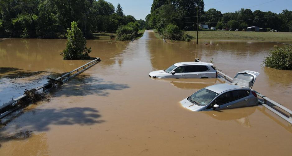
Cars were flooded when Back Creek rose above the bridge on Stone Street in the town of Haw River in Alamance County after the remnants of Tropical Storm Chantal swept through last weekend.
ŌĆ£In that sense, it feels like Chantal was ahead of its time of year, with much heavier rain and a much bigger impact than we usually see from these weak June or July tropical systems.ŌĆØ
People are also reading…
The path Chantal took to North Carolina, along with the heavy rainfall it brought, was largely the result of ŌĆ£luck of the draw,ŌĆØ said Charles Konrad, a professor of geography at The University of North Carolina at Chapel Hill.
ŌĆ£ThereŌĆÖs a lot of what we call inter annual variability in the number of strikes and also in the intensity,ŌĆØ he explained.
A cold front had passed through North Carolina days earlier of Chantal, bringing drier air and lower humidity, Konrad continued. That front then stalled over the Atlantic, allowing a circulation to develop, which eventually became Chantal.
While most systems that form in that part of the Atlantic at this time of year usually stay out to sea and drift north or northeast without making landfall, Chantal took an unusual path and moved northwest and then north, bringing it into the state.

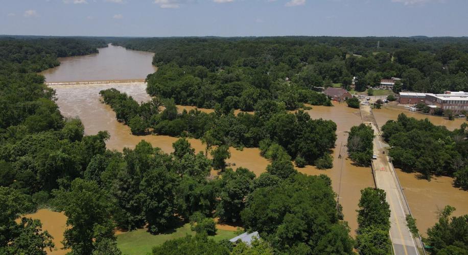
An aerial view of the rain swollen Haw River at Saxapahaw as floodwaters begin to recede on Monday.
ŌĆ£What really made the system distinct was the fact that it was moving slowly, and it maintained a lot of organization near its core,ŌĆØ Konrad added. ŌĆ£And by that, I mean that it was very effective in converging the air and lifting it over a small area, and then with it moving slowly, these places got an extra couple hours of really heavy rain and caused record flooding in some places.ŌĆØ
Tropical systems include everything from weak waves in the Atlantic to powerful hurricanes. Once a system shows signs of organization and has a closed circulation and concentrated thunderstorms, it can be classified as a tropical depression.
A tropical depression has maximum sustained winds of 38 mph or less. If those winds strengthen to 39 mph, it becomes a tropical storm and receives an official name. When winds reach 74 mph or higher, the system becomes a hurricane.
Chantal, for example, briefly became a tropical storm when it reached the required wind speeds off the Georgia coast, noted Davis. After making landfall in South Carolina, however, it quickly weakened back into a tropical depression as its winds dropped below tropical storm levels ŌĆö something that typically happens when storms move inland.
But weaker winds donŌĆÖt mean weaker rain. Tropical depressions can still soak an area because of all the moisture they pull in and release, Konrad said.

A man tries to communicate with crews that were trapped on Stone Street between two branches of Back Creek in Haw River after torrential rains on July 6-7.
The moisture pulled from the Atlantic is drawn toward the stormŌĆÖs center, where the humid air rises through convection ŌĆö a process in which warm, moist air moves upward. As the air rises, it cools and condenses, forming clouds and producing heavy rain.
Meanwhile, the tropical depression follows the National Oceanic and Atmospheric AdministrationŌĆÖs (NOAA) prediction of an ŌĆ£above-normalŌĆØ hurricane season.
ŌĆ£By August, IŌĆÖd expect the broader Atlantic basin all the way to the coast of Africa to see more activity, but thereŌĆÖs a solid chance that weŌĆÖll still see more storms closer to home as the season goes along,ŌĆØ Davis said.
ŌĆ£Water temperatures in the Gulf and along our coastline are warmer than average for this time of year, and that could favor more storms forming in those regions and more rapid intensification in those areas.ŌĆØ